GIS has always been a priority for asset management but now, with asset teams under pressure to ensure what they spend is needed, a reduction in rent means a reduction in asset spend. GIS provides a strategic insight into your assets more than any other system can allowing the information you hold on your assets to be readily available at your fingertips.
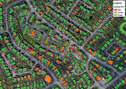
Using your property NPV Scores, GIS creates thematic maps to show concentrations of poor performing properties. Seeing them visually on a map helps to see properties with poor NPV in close proximity, aiding in the identification of potential development sites.

Analyse location of stock and staff to plan clearly for future expansion. GIS allows you to visualise what the larger organisation will look like and where services can be easily combined to save money.
Being able to view one organisations stock in comparison to the other organisations as well as things like neighbourhood patches, repairs patches and grounds maintenance helps decision makers to see where there maybe issues down the line or quick wins with regards to combining services.
Viewing your delivery programmes geographically can help other areas of the business to clearly understand where and when works are taking place.
Another benefit of having your programmes of works mapped in the GIS is the ability to compare this to repairs history to see if there are any gaps in your programmes. Also, the ability to quickly see the programme details against other stock data such as architype and land ownership.
Having access and a visual view of more data allows for more informed decision making and allows easier multi department workings.
How is your stock performing? Are maintenance plans going to schedule, are there areas where NPV is low and action is required?
Having your stock information mapped in a GIS allows for a different view of your data whether this be comparing to other internal information about an area or a property or viewing the data alongside open data sets.
GIS helps support strategic decision making by being able to easily interpret data and view it in a geographical way.
The tagging of assets enables the quick retrieval of information about an asset, should it be damaged and in need of repair or replacement. Having this information at your fingertips will obviously save time, both in reducing the need for a site visit but also in knowing immediately the specification of that asset. View the case study below of Asset tagging carried out for Stockport Homes.

GIS gives you the opportunity to analyse where your repairs are concentrated and to identify possible reasons for poor performance. Are your staff being utilised in the most efficient way? Route planning can help make site visits more productive.
It is incumbent on you as an employer to ensure your staff have access to WC’s and refreshments when they are out on site visits. Public WC’s, Cafes, Superstores etc who have facilities available, maybe identify an empty property that could be used? Having this information available on a GIS, especially if your staff have mobile access is extremely useful.
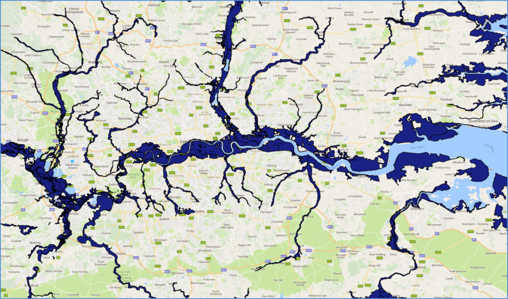
With more extreme rainfall, what are the chances of one of your properties being flooded? Are your properties affected by Radon? You need to take remedial action if they are. Identifying what stock is potentially at risk can be done very simply with GIS, putting your mind at risk and giving you a good news story to tell your tenants – you have been a responsible Landlord and checked, taken appropriate action and have a clean bill of health.